estimate of where each party would win if the US had a parliament with proportional representation
Nope. The regional divisions come from a video game.
estimate of where each party would win if the US had a parliament with proportional representation
Is it from one of the EU series? I'm not familiar enough with the series to explain exactly what I mean, but I'll try. I remember that some of the territories had a modifier that made them biased or predisposed to act in a certain way. For instance, in the New World, the colonies would be more likely to rebel.Nope. The regional divisions come from a video game.
It seems to correlate closely with the Civil War. Alaska and Hawaii would be irrelevant to a game specifically about the American Civil War but they're represented and each is unique
Shattered Union.
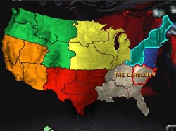
Well, the dark blue union with only four states and a weird border is totally indefensible. Even just adding Virginia would greatly improve their defence lines.

Well, the dark blue union with only four states and a weird border is totally indefensible. Even just adding Virginia would greatly improve their defence lines.

")
My guess is that it has something to do with immigrants from the Middle East ?
")
performance by country in the european championship, the gold squares indicate hosts

Population Density.Nice Kyr
Here a new one
Countries are distorted so that the country size is as big as what is shown
what is shown ?
View attachment 568174
Population Density.
It's you know I see the first world or whatever has the most of it but also India has more than China and I can't figure out what sort of thing that would be