If you took over the US how would you divide it?

A'AbarachAmadan said:
...so don't call us 'jesusland', it is offensive.

First of all, I would like to apologise about the map Ive made earlyer. As you can see. I am still not over with the elections.

With out further delay, I will post a new map here :).

Ive colored coded the map to there specific geographic location (Does not relate to Politics)
Blue States: The Northeast Corridor (In referance to the electrified railroad line between Boston, MA to Washington D.C. See Wiki: Northeast Corridor for more information) Other names in consideration are the Nor'easter, named after the frequent stomrms that hit the reagon in the winter time

Orange States: Appalachian Mountain Region (In referance to the mountan range with the same name)

Dark Green States: Deap South (Texas was hard to determane since some of it's terrain also lyes in a desert/arid region. In referance that they are closer to the equator and rarely witness any snow fall)

Light Green States: America's Bread Basket (In referance to the booming grain farm industry)

Pink States: America's Car Capital (In referance to the car manufacturing industries in the region. Both in the past and present such as Flint and Detroit)

Brown States: Mountan States (In referance that they are in the Rocky Mountan Range)

Yellow States: Desert States (In referance that they are in the desert/arid region of the US.

Red States: Pacific States (In referance that they border the Pacific Ocean. Typicly they have very dense forest twards the northern end and a stable wine industry in southern California) Other names for consideration is the Sowesters (other spellings: Sowwester, So'wester, Sow'wester) which is opposite of the storm system Nor'easter. If anyone has an offical name for this storm system. Please feel free to tell me.

Grey States: Deap Pacific States (In referances that they are far north or far west from the United States mainland. Typicly they have an offical interstate highway that does not connect to the mainland US. See Wiki's entery of Interstate Highway for more information
 
Although I don't have a map, I divide it into two areas. One is Miami and Hawaii which I will name the warm enough places. Everyplace else I label as too darn cold part of the year. :lol:
 
Hmm, something like ybbor said, into 4-6 separate countries.
 
A'AbarachAmadan said:
Although I don't have a map, I divide it into two areas. One is Miami and Hawaii which I will name the warm enough places. Everyplace else I label as too darn cold part of the year. :lol:
Well, what about southern california, most of the southern states (the counties that are not in the Appalachian Mountains), and The Desert States? ;)
 
CivGeneral said:
Well, what about southern california, most of the southern states (the counties that are not in the Appalachian Mountains), and The Desert States? ;)

I lived in Arizona, Alabama and Georgia. Thought they were all too cold in the winter, but that is because I'm now climatized to really hot weather. Even Miami is a little chilly for me.

Your second map is the best I've seen so far.
 
A'AbarachAmadan said:
I lived in Arizona, Alabama and Georgia. Thought they were all too cold in the winter, but that is because I'm now climatized to really hot weather. Even Miami is a little chilly for me.

Your second map is the best I've seen so far.
Thanks, on and that reminds me. I forgot to give the pink states there description :blush:.

Anyway, I do wish that everyone would partisipate and create there own US maps.

CivGeneral heads to #civfanatics to pass the word
 
A'AbarachAmadan said:
So how do you reconsile those of us that don't believe in God, but still voted for Bush. I'm an Arnold style Republican (centrist actually, but he comes closest to my beliefs), so don't call us 'jesusland', it is offensive.
or those democrats who live in "red america" who are pagans (not me, but 2 of my friends)
 
Chairman Meow said:
I'd separate the redneck parts from Maryland and let the rest of it (plus Washington DC) float out to sea. Take that, Baltimore!
heyyyy... :(
remember, that includes me.
 
@CG: i notice one thing about our maps, under my map you would have 3 democratic areas and 3 republican ones ( not counting AK/HW because i have no idea what to do with them) under your map we'd have 4 republicans and 2 democrats, with 3 swing areas (grey, pink, green) i question some of your divisions (is pink really that different from green? is yellow different from brown?), may i ask what criteria you had for what a is required to from a new region? i based mine on how i saw differences in the way people think (people from oregon think different than people from idaho, but do people from colorado think different from people in new mexico?)
 
ybbor said:
@CG: i notice one thing about our maps, under my map you would have 3 democratic areas and 3 republican ones ( not counting AK/HW because i have no idea what to do with them) under your map we'd have 4 republicans and 2 democrats, with 3 swing areas (grey, pink, green) i question some of your divisions (is pink really that different from green? is yellow different from brown?), may i ask what criteria you had for what a is required to from a new region? i based mine on how i saw differences in the way people think (people from oregon think different than people from idaho, but do people from colorado think different from people in new mexico?)
I based my new map on geographical and/or industrial influences. Not on politics. For example, I clumped the pink states as the region of the American Automobile Industry the light green states as the American Bread Basket since that region is known for the agricultural prosperity. Texas was a tricky state to place since its in the deap south and some of the Texan landscape has a few patches of desert/arid areas inland.
 
I would simply made of both Dakotas a single state.

Afterwards, I believe the Electoral College is more important to reform than state boundaries. No one talks anymore about it, haven't you noticed ?
 
CivGeneral said:
I based my new map on geographical and/or industrial influences. Not on politics. For example, I clumped the pink states as the region of the American Automobile Industry the light green states as the American Bread Basket since that region is known for the agricultural prosperity. Texas was a tricky state to place since its in the deap south and some of the Texan landscape has a few patches of desert/arid areas inland.

but do car manifacturers really think differently enough to warent their own region?
 
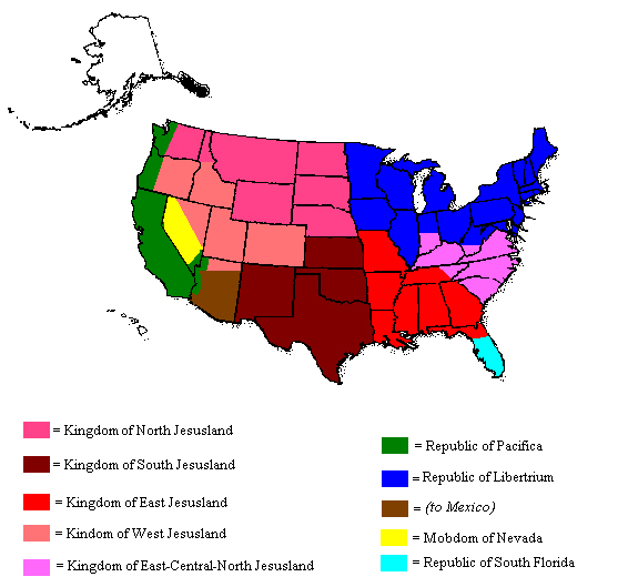
Here's my map. My theory is that by dividing Jesusland, I can make it weak. They'll be too busy deciding which prayers should be mandatory in public schools to care about anything beyond their Kingdoms. I couldn't figure out what to do with Alaska and Hawaii. Maybe the latter will be given to Hawaiian nationalists, and Alaska could be returned to Russia. I have decided to return Arizona to Mexico, just for the sake of irony, so that they won't be able to say, "You is in the US now, you needs to speak Eng-gi-lish instead of your Mex-i-can-ese." [j/k] :D

EDIT: Move the part of Nevada near Carson City that was given to California a little south (but just a little) so that it can include all of Lake Tahoe! :D

simsnation.jpg


Note that this is not a serious map.
 
I've thought about this many times. It depends on the circumstances. Is the entire country still unified, but mine to subdivide? Or, rather, has the federal government dissolved and now the states, newly sovereign nations, vie for land area? In the first case, I would simply try to make the states a more equal size. Big ones would be broken apart, little ones would be combined, until all the states were about the size of Kansas. In the second case, only a few large regions would emerge as powerful states consumed their neighbors, and like-minded states confederated.
 
CivGeneral said:
Red States: Pacific States (In referance that they border the Pacific Ocean. Typicly they have very dense forest twards the northern end and a stable wine industry in southern California) Other names for consideration is the Sowesters (other spellings: Sowwester, So'wester, Sow'wester) which is opposite of the storm system Nor'easter. If anyone has an offical name for this storm system. Please feel free to tell me.

For one thing, Californians (at least Bay Areans) hate being glopped into the Southwest. Also, the wine industry is in northern California. And the term So'wester is one that will just have people in all three states scratching their heads about. Good job on your map, btw. :goodjob:
 
Wouldn't divide it at all.
 
Bronx Warlord said:
I would shoot dead any invader, hang them from street lights and rally the american public to my banner, then I would nuke the ever living crap out of the hell hole they came from, the continent it's on, and then invade them.

:)
Finally, a man of common sense. Seriously, that was awesome... when can we get started? :D


Let's see. I would like the good states (IE, the blue ones) to break away from the bad states (IE, the red ones). This is a great idea, in theory, as Republicans would no longer dominate us against our will. It'd also be nice not to have to acknowledge that George W. Bush is my President! ::shivers:: We could call the new blue nation "Caliyork". Unfortunately, I don't think this would work. We have too many enemies all over the world waiting to pounce on it. We'd probably end up electing a President just as bad as Bush, on the other end of the spectrum. We might elect an American version of Chirac, for example and I don't think I'd be able to take that.

So, let's keep the Union intact. Here's what I recommend.

1) Give Hawaii it's independence. No use hanging on to it, no need for Naval bases in the Pacific when we already have some in Japan. It's disconnected from the states, for another thing. Lastly, there are many in Hawaii who want their independence. I say let them have it.

2) Alaska just bugs me. It doesn't make any freakin sense for it to belong to the states, being so damn far away and disconnected. I propose we trade Alaska to Canada for a piece of British Colombia and a first round pick in the next draft. A piece of any Canadian province connected to America would work instead of BC, just so long as it's not Quebec. Perhaps some of the province north of Maine (though I forget which state that is)

3) Other than that, I propose we merge some of these incredibly small states into nearby larger ones. Merge New Hampshire and Vermont with Maine. Merge Connecticut and Rhode Island with Mass. Merge New Jersey with New York. Merge Maryland and Deleware with Pennsylvania. Give that piece of land north of Wisconsin to Wisconsin, instead of Michigan. Seriously, does anyone know why that land belongs to Michigan to begin with? :confused: To compensate Michigan we can make Michigan and Ohio into a single state. Also, let's combine Indiana and Illinois. Square off Idaho by giving them the necessary pieces of Montana to do so. Then combine the left over piece of Montana with the full state of Wyoming. Finally, combine the two Dakota's.
 
Back
Top Bottom