NedimNapoleon
Weird Little Human
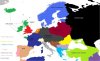
1400's its not completely accurate, Bosnia Croatia Serbia and Zeta are but others I'm not sure


To say the least. By the 1400s the Byzantine state had ceased to control Makedonia, Paionia, much of the Thraikian hinterland, and Thessalia. You've mis-colored Lakonia as something independent (unless you want to take the line that the Despotate of the Morea was fully independent after the late 14th century, certainly a valid conclusion but one that does not fit with Byzantine Achaia), while Achaia could be nominally correctly assigned to the Byzantines if it's sufficiently late in the century.1400's its not completely accurate, Bosnia Croatia Serbia and Zeta are but others I'm not sure
")
What the hell happened to the Gulf of Bothnia?

Russia is dark.
Africa and China are in the dark, man Europe is really addicted to Facebook