You are using an out of date browser. It may not display this or other websites correctly.
You should upgrade or use an alternative browser.
You should upgrade or use an alternative browser.
Altered maps VIII: World borders just got garbage-dayed
- Thread starter gangleri2001
- Start date
- Status
- Not open for further replies.
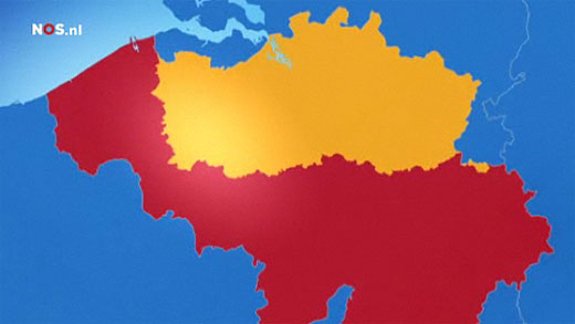
The Dutch television channel NOS used the following map of Belgium recently:
That same week the French television channel TF1 used the following:
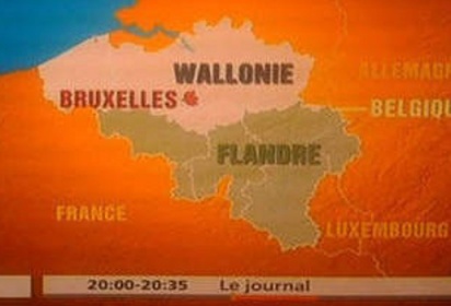
(I highly suspect that was done on purpose)
Maps often cause a whine-fest in Belgium, by the way. Some Francophone groups got offended by the following maps the Flemish Ministry of Tourism used:
 (notice 'Belgium' to the South)
 (France borders to the South, instead of Wallonia).
On both maps Brussels is included to Flanders.
Now, the following is a map ignored in the Flemish Region, and didn't cause a fuss at all. I have scanned this myself, but the map was too big to do it properly. This map is unknown by the overwhelming majority here.

Uploaded with ImageShack.us (a corridor has been drawn between Brussels and Wallonia).
That same week the French television channel TF1 used the following:
(I highly suspect that was done on purpose)
Maps often cause a whine-fest in Belgium, by the way. Some Francophone groups got offended by the following maps the Flemish Ministry of Tourism used:
On both maps Brussels is included to Flanders.
Now, the following is a map ignored in the Flemish Region, and didn't cause a fuss at all. I have scanned this myself, but the map was too big to do it properly. This map is unknown by the overwhelming majority here.

Uploaded with ImageShack.us (a corridor has been drawn between Brussels and Wallonia).

TheLastOne36
Deity
- Joined
- Jan 17, 2007
- Messages
- 14,045
I was bored on MS Paint, so I came up with this:

This is a little sketch up of a realistic-ish Greater Poland. (Including post-45 border to the west, which is cut off by the map I used). I was lazy with Silesia, so I just drew a line between Czech Republic and Poland. I drew in some major Polish cities myself which was fairly labor intensive.
I also quite like my name for Belarus.") (although I now realize it should be "Byeloruthya" instead of "Byeloruthia")
(although I now realize it should be "Byeloruthya" instead of "Byeloruthia")
This is a little sketch up of a realistic-ish Greater Poland. (Including post-45 border to the west, which is cut off by the map I used). I was lazy with Silesia, so I just drew a line between Czech Republic and Poland. I drew in some major Polish cities myself which was fairly labor intensive.
I also quite like my name for Belarus.
(although I now realize it should be "Byeloruthya" instead of "Byeloruthia")warpus
Sommerswerd asked me to change this
You've got Bydgoszcz where you should have Bialystok.
Mowque
Hypermodernist
TheLastOne36
Deity
- Joined
- Jan 17, 2007
- Messages
- 14,045
You've got Bydgoszcz where you should have Bialystok.
Doh!
I typed Bydgoszcz instead of Bialystok.

TheLastOne36
Deity
- Joined
- Jan 17, 2007
- Messages
- 14,045
Anyway, for anyone who hates the Central vs Eastern Europe debate, The above map shows all that it takes to make us shut up! 

thomas.berubeg
Wandering the World
Spoiler :

I'm the HRE, started as Milan, and it's 1579. Great Britain exists only on the continent, after owning all the british isles, they collapsed, lost to Scottish rebels, northumberland rebels, and most of England to papists rebels... which I then inherited as the the HRE.
Mowque
Hypermodernist
")
Mowque
Hypermodernist
Note- I didn't actually make either of these maps. I had others fulfill my TL visions.
This is about the best I can turn out. LOL
Note- this is roughly 1940 of the same world. Rough Draft.
Well, I like that one is even better.

amadeus
rad thibodeaux-xs
The TL?
sophie
Break My Heart
The TL?
Time Line. He's using Alternate History jargon:
OTL: Our timeline (the historical occurrence)
ATL: Alternate timeline
TTL: This timeline
PoD: Point of Departure (The point at which an ATL diverges from OTL)
Mowque
Hypermodernist
Time Line. He's using Alternate History jargon:
OTL: Our timeline (the historical occurrence)
ATL: Alternate timeline
TTL: This timeline
PoD: Point of Departure (The point at which an ATL diverges from OTL)
Yes, sorry. I've been hanging out with hat crowd so long I forgot other people might not have heard of it. Basically it is the world behind that map.
thomas.berubeg
Wandering the World
P.o.D: also, point of divergence
- Status
- Not open for further replies.
Similar threads
- Replies
- 564
- Views
- 29K
- Replies
- 1K
- Views
- 98K
- Locked
- Replies
- 1K
- Views
- 54K
- Replies
- 1K
- Views
- 55K