You are using an out of date browser. It may not display this or other websites correctly.
You should upgrade or use an alternative browser.
You should upgrade or use an alternative browser.
Altered maps XI: Towards a New Decade!
- Thread starter Civ'ed
- Start date
- Status
- Not open for further replies.
mayor
Heart & Mind


Winner
Diverse in Unity
My eyes started bleeding again 
NedimNapoleon
Weird Little Human
I found it on the History channel and shared it with you guys, its an abomination. It represents nothing.
CELTICEMPIRE
Zulu Conqueror
I found it on the History channel and shared it with you guys, its an abomination. It represents nothing.
I knew the history channel was bad, but not, that bad.
hoplitejoe
Top fun-poster
- Joined
- Mar 22, 2010
- Messages
- 5,470
There is also an issue with a Libyan city flashing up in Romania.....
uat2d
ಠ_ಠ
I knew the history channel was bad, but not, that bad.
Wait, weren't the aliens enough?
I don't understand that map. Is the big deal just that it makes no sense from both geographical and historical standpoints? What is it from?
It is a big deal if it is trying to represent geographic and historical facts, which it seems that it is trying/failing to do.
Moderator Action: We get it, it's a bad map. Moving on . . .
Mad Man
Your lord and master
Why is Rhineland listed as a country but not Luxembourg?
Because Luxembourg is small and irrelevant, and has a big name that covers a lot of the map. No offense to any Luxembourgers, but it didn't have the size to do anything of significance on its own. Note that several other countries also aren't labelled.
The Rhineland would presumably be important when it was showing earlier events as this appears to be a screen capture of an interactive timeline and probably include the remilitarization of the Rhineland (the marker in 1936).
Basically it comes down to, the Rhinland is more significant to the map than Luxembourg. Though, if making the map I would make the label for the Rhineland distinct from countries, that is the least of the map's problems.
The strangest thing about the map to me is that it is apparently based on a late 1990 or 1991 map (unified Germany with modern borders, but still an USSR, the baltics could indicate late 1991 or more likely refusal to recognize their annexation by the USSR). I could see a modern map or a contemporary map, but why that period?
Then what the map is supposed to be showing I have no idea. I would guess countries occupied by Germany at some point in time, but is grossly wrong.
aronnax
Let your spirit be free

TheLastOne36
Deity
- Joined
- Jan 17, 2007
- Messages
- 14,045
I like how the mormon state is represented in those graphs.
gangleri2001
Garbage day!!!
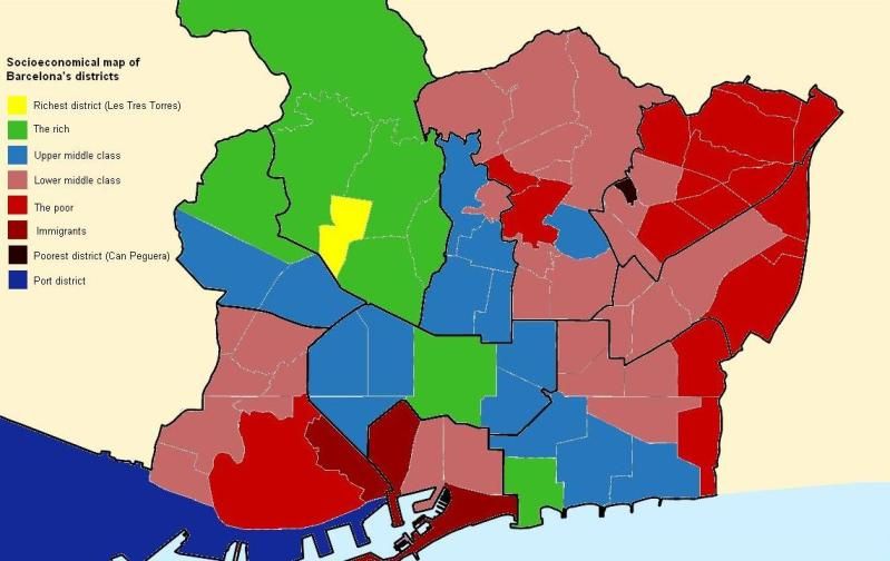
Here's a map I just made from recently published data by Barcelona's mayor's office.
gangleri2001
Garbage day!!!
Why does the Port District not fit in with any of the others?
O_O
Mainly because it's a port and there're only ships, containers, roads and warehouses, you know?
- Status
- Not open for further replies.
Similar threads
- Replies
- 559
- Views
- 29K
- Replies
- 1K
- Views
- 98K
- Replies
- 1K
- Views
- 109K