Map of America - The Midwest

Downtown, you recently drove through Missouri, right? How would you compare Columbus to Cleveland to, oh, Kansas City to Columbia? The times I have driven through Ohio, I've always been struck at how dense it is compared to Iowa, Nebraska, Kansas, and even Missouri.

Honestly, the drive between any of the three urban areas in Ohio is going to be full of a whole lot of nothing. There is some suburbia about 40 min outside of Cleveland and Columbus, but there is a whole lot of nothing in between...lot of farms, lots of tractor XING signs, etc.

Thats the big reason why Ohio is a swing state just about every year...because it has several urban areas (but no single dominant urban area), but a ton of rural farming areas (and farming interests) as well.

I'm trying to get a little county by county map up here, so I can show you where Appalachia starts, and where the suburban areas are
 
Any state that plays football in the Big Ten is midwest (except Pennsylvania because they came late and needed a conference). I think Bamspeedy's map makes the most sense.
 
Don't you mean the old Big 8, before the Texas abominations joined and made it the big 12?
 
There is no need for an Appalachia region to be shown on a cultural map. Appalachia is a part of The South culturally, no question about it.

You have Cleveland and Philly in Appalachia. Not too good there.
 
Fun Fact! Texas tried to join both the Big 10, and the Pac-10, before they joined with the Big-8(12), despite not being in the Midwest or the West Coast. They felt the academic standards of the Big 8 institutions were lacking....

Kinda wish the Big 10 had broken its bylaws and let that happen. We would be unstoppable.
 
I thought Oklahoma was in the Midwest.
There have been so many maps used in the school classroom here.
Once it was part of the Southwest, then Midwest, now South?
Oklahoma didn't have such a big problem with race (it did have some don't mistake me) like the deep south.
 
Btw, Downtown, I'll naturally defer to you on the population thing in Ohio. You're the one that lives there, after all. ;) It's just that I really always do get a totally different feel when I hit Ohio as opposed to the midwestern states.
 
Mizzou will have to make it to the Big 12 championship first - although given that it plays in the Big 10 South, that might not be that tall of an order to fill.

Is the Big 12 South really any better? Texas was good one year with a once in a generation player and has been mediocre the rest. Tech will choke per usual
 
Yes, Appalachia is all sorts of messed up, I wasn't very exact with it, partially because I'm not very exact with knowing where its boundaries are. Not far enough south, too wide, I know. Can we assume the rest looks alright since no one seems to be taking issue with it?
 
I thought Oklahoma was in the Midwest.
There have been so many maps used in the school classroom here.
Once it was part of the Southwest, then Midwest, now South?
Oklahoma didn't have such a big problem with race (it did have some don't mistake me) like the deep south.
Oklahoma is no man's land. The regions of the country are the Northeast, Midwest, Southeast, Southwest, Intermountain West, West Coast and Oklahoma.
 
By the way, if you're going to be splitting up the US culturally South Florida is NOT anything at all like North Florida.
 
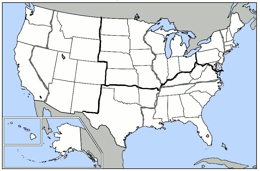
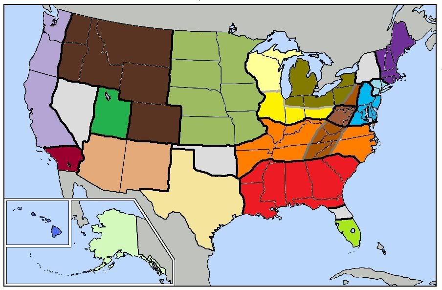
I've made two maps dividing America. The first is divided Geographically between Northeast, Midwest, South, and West. Each one of those regions has a cultural split in it. The second map is divided purely on culture.

Thick black lines are geographic boundaries and gray lines are culture:

fcb67803.jpg


1. Northeast
a. New England
b. Mid-Atlantic

2. Midwest
a. Great Lakes States
b. Great Plains

3. South
a. Deep South
b. Upper South (thinking back on it, NC and TN are probably better described as Upper South, but I'm too lazy to change it)

4. West
a. Mountains
b. Pacific

The thick black lines are regionally borders. The light gray lines mean there is a sub-region. The dark gray lines means there is a combination of regions.

8f6b1088.jpg


green-yellow: South Florida

red: Deep South

orange: Upper South

brown: core Appalachia
light brown: Appalachia/Upper South combo and Central Pennsylvania (I'm actually not sure what to classify Central Penn as. Pennsylvania Dutch maybe?)

light blue: Mid-Atlantic

sky blue: New Yawk

purple: New England

yellow: Great Lakes States
dark goldish color: Rust Belt
light yellow: area has many similarities to Great Plains, but still think it belongs in the Great Lakes States.

light jungle green: Great Plains

peachish color: Texas Stands Alone :cowboy:

sandish color: Mojave/Southwest

dark brown: Mountains

green: Utah

lavender: Pacific Coast

that reddish purplish color: Southern California

Alaska and Hawaii need no explanation

light gray: these I wasn't sure what to label
Nevada: I'm not really sure what to label it
Oklahoma: South and Great Plains combo
Central Florida: I wasn't sure where to put the Deep South/South Florida line
Upstate New York: Not sure what to label it. Upstate New York would probably be the best label.

additional note: some cities are quite different than the rest of the region they are in, but I didn't see it necessary to give them their own regions. Chicago, Minneapolis/St. Paul, and Denver are probably the best examples.
 
Nevada is Mojave/Southwest.

edit - Yeah I have heard that about Idaho and Utah too, in fact I have heard that Idaho is more Utah then Utah is.
 
I think that the solid red states are the only midwest states.
 
Back
Top Bottom