You are using an out of date browser. It may not display this or other websites correctly.
You should upgrade or use an alternative browser.
You should upgrade or use an alternative browser.
Altered maps IZ: gib clay!
- Thread starter Takhisis
- Start date
- Status
- Not open for further replies.

That sea looks like interwar Poland.
mitsho
Deity
mitsho
Deity
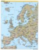
...but... what is it? There are some east-west/neighbour swaps in there, but there is more stuff, which I can't place.
Oh, it's just a huge number of extremely minuscule changes that are supposed to drive you crazy. Already seen the Malta-Crete swap? Catalonia in Basque? That Ireland moved north to be besides Scotland? That Strasbourg is right, but on the other side of the Rhine? That we have Leningrad AND St. Petersburgh? And whatever Lithuania did? That Geneva and Genoa switched places?
It's great because as it is stated on the bottom right: Boundary representation is not necessarily authoritative.
") It's just a silly thing, a map to explore and find all the mistakes.
It's just a silly thing, a map to explore and find all the mistakes.warpus
Sommerswerd asked me to change this
This map is triggering me
Where is my safe map space
Where is my safe map space
Josu
Emperor
What a wonderful master piece!!
Love it
amadeus
rad thibodeaux-xs
I saw on the news that Iran has denied attacking an Omani tanker, but what stood out to me is the foreign affairs minister's backdrop, a section of which I captured for us to enjoy.

What the heck is going on in here?
What the heck is going on in here?
Zardnaar
Deity
I saw on the news that Iran has denied attacking an Omani tanker, but what stood out to me is the foreign affairs minister's backdrop, a section of which I captured for us to enjoy.
View attachment 604150
What the heck is going on in here?
Iranian geography lessons not great. Sill there's some great countries on that map.
amadeus
rad thibodeaux-xs
I saw on the news that Iran has denied attacking an Omani tanker, but what stood out to me is the foreign affairs minister's backdrop, a section of which I captured for us to enjoy.
View attachment 604150
What the heck is going on in here?
No one cares about Indonesia/dinoGuinea/pacific archipelago

amadeus
rad thibodeaux-xs
I don’t think we can say for certain that it was a deliberate choice—with the map’s poor quality of assembly, I think it’s as equally likely they glued Iran on the wrong spot, had to pry it off, and then they didn’t bother to scrape off the leftover glue; notice how the shape of the discoloration is the same as Iran itself.
What are those weird white landmasses in the middle of the Pacific, to the northeast of Australia?What the heck is going on in here?
- Status
- Not open for further replies.
Similar threads
- Replies
- 559
- Views
- 29K
- Replies
- 1K
- Views
- 98K
- Replies
- 1K
- Views
- 109K
- Replies
- 1K
- Views
- 132K