Altered Maps XIV: Cartographical Consistency

16053_THUMB_IPAD.jpg


Mmm fries
 
Oh huh. Good catch. Maybe whoever made the map couldn't find that info or forgot? :dunno:


EDIT: Yere is wikipedia's map, maybe it's more accurate

Spoiler :

2000px-McDonaldsWorldLocations.svg.png
 
The first thing I try to read are the relations of Pakistan, and to me it seems like it says Pakistan is both a friend of Libanon, and that there is uncertainty between Pakistan and Libanon.
 
"Note: Palestine and Israel were discounted for the sake of simplicity."

Thank god. Good thing they opted to keep it clean and tidy.
 
attachment.php


Redrawing the Australian states primarily to make the Murray-Darling Basin its own state so it can solve its allocation problems as a single entity instead of spanning four states.
 

Attachments

  • redrawnstates.PNG
    redrawnstates.PNG
    23.5 KB · Views: 298
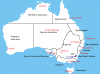
It's our biggest river system by a wide margin, where most of our agricultural (and wine) land is. Water quality, water access, salinity and ecological damage have been a huge issue for decades due to the fragmented governance of the area (Queensland, New South Wales, Victoria and South Australia all have a big interest in the basin).

It boils down to: 11.5 of 13 GL of divertable flow and 24 GL average total flow are removed for different uses. About 95% is agricultural use including rice and cotton. That much removal leaves way less than enough for the environmental requirements to maintain the health of the rivers.
 
Why is there no city between Sydney and Melbourne?

(or is that merely not warranting its own province for other reasons? Eg river system related)

Along the coast there's only Wollongong, about an hour south of Sydney. It's not really worth making Illawarra its own state, it's only a about half the size of Newcastle. South of Wollongong is just small towns, and east of Melbourne around the south-eastern corner there's mostly national park and very little settlement.

There's no other cities along the coast between Sydney and Melbourne, and the inland side of the Great Dividing Range is MDB with Canberra carved out.
 
The Scandinavian results vary wildly according to whether the survey is carried out in summer or in winter. *back to the crapal-tunnel cave*
 
Back
Top Bottom