You are using an out of date browser. It may not display this or other websites correctly.
You should upgrade or use an alternative browser.
You should upgrade or use an alternative browser.
The Ultimate Map Thread
- Thread starter Abaddon
- Start date
Abaddon
Deity
Why didn't they get anywhere?
Anonymoose
KING OF MEESE
Looks like people were complaining too much about rules and the map wasn't pretty enough. I would have played that NES as long as Gelion allowed it. I crave a DuneNES like a cheetah craves gazelle meat.
Gelion
Retired Captain
Why didn't they get anywhere?
Mainly because as a NES they are either good for a full boardgame or a very motivated crew. Up until recently I had too many online things going on at the same time to fully commit to anything.
Looks like people were complaining too much about rules and the map wasn't pretty enough. I would have played that NES as long as Gelion allowed it. I crave a DuneNES like a cheetah craves gazelle meat.
You're right the game design wasn't finished. As for the map, I still can't produce a multi-layered map, the kind I would need for this NES.
Still, if the design goals are clear enough I could participate in making of this game. With the right approach, this could be a fun NES to play.
Kraznaya
Princeps
If I could open my arms
And span the length of the isle of Manhattan,
I'd bring it to where you are
Making a lake of the East River and Hudson
If I could open my mouth
Wide enough for a marching band to march out
They would make your name sing
And bend through alleys and bounce off all the buildings.
I wish we could open our eyes
To see in all directions at the same time
Oh what a beautiful view
If you were never aware of what was around you
And it is true what you said
That I live like a hermit in my own head
But when the sun shines again
I'll pull the curtains and blinds to let the light in.
Attachments

Kraznaya
Princeps
The only part that 2008 cities screwed up is me forgetting to get rid of Brasilia and move the capital :3
Kraznaya
Princeps
Which cities didn't exist? Size doesn't matter, but that does =/
Cities aren't the important thing. BTW I changed some stuff on the map that either a) was impossible to reconcile between the old crappy map and the newer, accurate one or b) had an outcome in the timeline that was stupid. (Like Alsace-Lorraine.  No, I mean seriously - giving up Nordschleswig, fine. Giving up Posen, fine. Giving up Alsace-Lorraine...um, wanna give the French the Rhineland and Swabia while you're at it? Makes just about as much nationalistic and economic sense. No way in hell this was on any German Communist agenda, much less one that had a chance of commanding any support whatsoever among the population.) Also it's still not perfect obviously enough and I'm kind of unhappy about how I did eastern Asia (probably took more distortion into account than I needed to) but at least it's better than either of the alternatives.

No, I mean seriously - giving up Nordschleswig, fine. Giving up Posen, fine. Giving up Alsace-Lorraine...um, wanna give the French the Rhineland and Swabia while you're at it? Makes just about as much nationalistic and economic sense. No way in hell this was on any German Communist agenda, much less one that had a chance of commanding any support whatsoever among the population.) Also it's still not perfect obviously enough and I'm kind of unhappy about how I did eastern Asia (probably took more distortion into account than I needed to) but at least it's better than either of the alternatives.Spoiler edited map :
Abaddon
Deity
I've not updated fore ages. Important maps for the OP?
Northen Wolf
Young Hunter
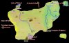
Spoiler picture :
I want to finish this, but it looks like "something" is wrong with this map.
And how do you make "nice looking" "shroud" (the black border/unknown area) erm nice? My cuts (made with lasso tool) were too "edgy" that's why I used the "pale yellow" border.
Hmmh, I guess I should reduce the back blur of the names?
Attachments
nutranurse
Unlikeliest of Slash Fics
- Joined
- Jan 30, 2009
- Messages
- 2,077
Well, as to the shroud, if you use photoshop or anything with layers then just throw a new layer ontop of everything, take your tablet (if you own one, if not use a mouse) and grab a big, black brush and go over areas that you want covered. It will certainly look a lot more fluid than lassoing.
Also, I like the blur around the names- what do you think is wrong with it?
Also, I like the blur around the names- what do you think is wrong with it?
Northen Wolf
Young Hunter
Well, as to the shroud, if you use photoshop or anything with layers then just throw a new layer ontop of everything, take your tablet (if you own one, if not use a mouse) and grab a big, black brush and go over areas that you want covered. It will certainly look a lot more fluid than lassoing.
Also, I like the blur around the names- what do you think is wrong with it?
Spoiler :

So... I think it looks better now, forests should be bit bigger.
Edit: fixed blur.
nutranurse
Unlikeliest of Slash Fics
- Joined
- Jan 30, 2009
- Messages
- 2,077
Looks nice, the forests really do help to break up the scenery a bit (though centaur forest is kind of close to the desert, don't you think?) And yes, making them larger would be good. As they are now they are kind of arbitrary green blobs!
The repositioning of names and such really helps with getting a better understanding of who owns what and where each state is, so kudos on that. I guess you reduced the glow size around the letters? It's fine either way, though some may prefer this less-glow version.
The repositioning of names and such really helps with getting a better understanding of who owns what and where each state is, so kudos on that. I guess you reduced the glow size around the letters? It's fine either way, though some may prefer this less-glow version.
Bil
Prince of Space
"Clownscull Swamp" might be the best name I've ever heard.
ryaz
Chieftain
Is there any Northern-style maps of the world between 1917 to 1924?
Is there any Northern-style maps of the world between 1917 to 1924?
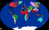
Have a map from 1923:

EDIT: If anyone wants to fix the borders of Poland, go ahead.
ryaz
Chieftain
Thanks.
EDIT: Since I'm not planning on improving the map, but altering it (most European borders are going to be changed), I'd also like to note that the Free State of Fiume isn't represented.
EDIT: Since I'm not planning on improving the map, but altering it (most European borders are going to be changed), I'd also like to note that the Free State of Fiume isn't represented.
Northen Wolf
Young Hunter
Well, I think it's ready for use now.
I think decent quality:time ratio for my skills")

I think decent quality:time ratio for my skills
Spoiler :
Similar threads
- Locked
- Poll
- Replies
- 11
- Views
- 2K
- Replies
- 50
- Views
- 7K