You are using an out of date browser. It may not display this or other websites correctly.
You should upgrade or use an alternative browser.
You should upgrade or use an alternative browser.
Altered maps IZ: gib clay!
- Thread starter Takhisis
- Start date
- Status
- Not open for further replies.
It is astounding that folks still use the Mercator projection for anything.
What is the deal with Japan?
amadeus
rad thibodeaux-xs
The rate of 3.2% for this year has appeared once before in 2010ish, otherwise it has been in the under 2.5% group; the FAO does not calculate percentages below 2.5% due to some difficulties.What is the deal with Japan?
I would hazard to say that it is an anomaly that might be resultant of some kinds of data collection or calculation error rather than a worrying sign of malnutrition.
AdamCrock
Polish Pirate
Never forget thet statictics are a tool to show the rest of the world : "we are doing fine" , they can be falsified.
Last edited by a moderator:
Also in Mongolia population is heavily skewed towards the capitol. Exclude Ulaanbaatar and it is really empty. These maps give some idea, see that the bottom scale of the mongolia one is ~1/3rd as populated populated than the US one.


Spoiler Scale :
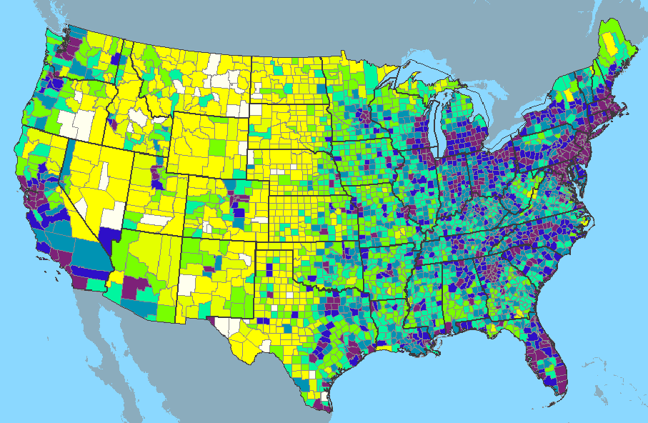
2000 U.S. population density in persons per sq. mile (contiguous U.S. only). Averaged on a per-county basis.
Legend, light to dark (white to violet):
0-1 (mint green)
1-4 (pink)
5-9 (blue-green)
10-24 (orange)
25-49 (teal)
50-99 (lime green)
100-249 (dark blue)
250-66,995 (violet)
Legend, light to dark (white to violet):
0-1 (mint green)
1-4 (pink)
5-9 (blue-green)
10-24 (orange)
25-49 (teal)
50-99 (lime green)
100-249 (dark blue)
250-66,995 (violet)
the northern central plains is empty because it is mostly farmland or empty of resources. In addition is very cold (currently) in winter. The western areas are popular for visiting in summer. That big space is farm and ranch land with few cities. NM is similar; it is a big state with low density except for Albuquerque: farm land, oil land, national forests, ranch land. Low density. The US has vast areas with very few people.
The area is about 1000 miles across by 400 or so miles north to south. Mongolia is a bit bigger: 1200 miles across by 500 deep.
Here is a map of the government owned forest land in the US. They own more under different auspices.

The area is about 1000 miles across by 400 or so miles north to south. Mongolia is a bit bigger: 1200 miles across by 500 deep.
Here is a map of the government owned forest land in the US. They own more under different auspices.
Broken_Erika
Play with me.
bene_legionary
Believes in love
That is one weird map. If I had my other username I'd be ruling Bene : )
I wonder where Luxemburg and Istanbul went...
I wonder where Luxemburg and Istanbul went...
~Corsair#01~
Deity
At first you think the map look ridiculous, but then you see Austroslovakia.
Istanbul needed to be harvested so Bulgreece would have the resources to conquer Crimea.That is one weird map. If I had my other username I'd be ruling Bene : )
I wonder where Luxemburg and Istanbul went...
The spice must flow.Istanbul needed to be harvested
AdamCrock
Polish Pirate
"For he who would deny You access to information dreams himself Your master"
nice video btw.
The world does not begins and ends at Greece You know ...At least eastern Thrace, yes. To sort of look like pre-first crusade Komnenian empire. Add former Fyrom too.
Then again, eastern Thrace doesn't seem to even exist in the map.
- Status
- Not open for further replies.
Similar threads
- Replies
- 555
- Views
- 29K
- Replies
- 1K
- Views
- 98K
- Replies
- 1K
- Views
- 109K
- Replies
- 1K
- Views
- 132K


