You are using an out of date browser. It may not display this or other websites correctly.
You should upgrade or use an alternative browser.
You should upgrade or use an alternative browser.
Altered maps VIII: World borders just got garbage-dayed
- Thread starter gangleri2001
- Start date
- Status
- Not open for further replies.
sophie
Break My Heart
Dacia, Illyria, and Epirus are the big ones for me. It's not that there's anything necessarily wrong with them, they just kind of rub me the wrong way.
Dacia, Illyria, and Epirus are the big ones for me. It's not that there's anything necessarily wrong with them, they just kind of rub me the wrong way.
So you want them to be split up into more provinces? Not happening; there are already too many.

The Cyclades should be separate though, especially in the Mediterranean. Lots of people like claiming islands.
There's Rhodes...
From here:
http://alphadesigner.com/project-mapping-stereotypes.html
According to Britain

Where the artist lives:

According to Italy:

http://alphadesigner.com/project-mapping-stereotypes.html
According to Britain
Where the artist lives:
According to Italy:
I checked out the site.
I find it funny that Finland is Cell Phones to everyone. He should make a map of "Europe according to Finland" or "Europe according to Sweden" just so there's one that isn't Finland=Cell Phones.
I find it funny that Finland is Cell Phones to everyone. He should make a map of "Europe according to Finland" or "Europe according to Sweden" just so there's one that isn't Finland=Cell Phones.
madviking
north american scum
They got the French one all wrong, this is Europe according to France:

Fixed.

Graceheart the Leopard
Resident Amur leopard
- Joined
- Sep 24, 2007
- Messages
- 3,476
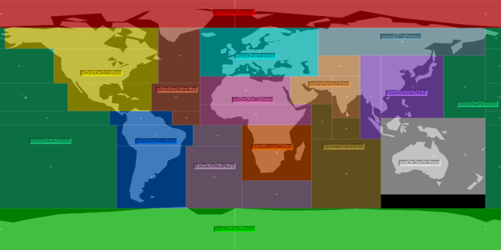
The world as seen from Paris:

Strange Maps's commentary:
Strange Maps's commentary:
In 1989, Swedish author Herman Lindquist published Rapporter från Mittens Rike (‘Reports from the Middle Kingdom’). The title of the book is ambiguous, as it refers to the well-known epithet for China that has come to symbolise its insularity and self-centredness in previous centuries. In this context, the term Middle Kingdom might be interpreted as a reference to France’s continuing tendency to see itself as a major player on the international political, economical and cultural stage, while in fact it is now a medium-sized power at best – as are all other European countries separately.
I haven’t read the book, but Rickard Hansen has. He sent in this map, included in the book. It appears to be a (rare) example of French self-deprecating humour: “The author says that the map was produced originally by a French magazine called Actuel.”
Mr Hansen, a Swede who lives in France, can vouch for the reality of some of the views/prejudices presented on the map: “The majority of French really do think that there is some sort of permanent winter in Scandinavia (…Being Swedish, I think the French drive like crazy, they in turn think the same about Italians, and apparently it’s a good idea to lock the car there too!”
Some other characteristics of le monde, vu de Paris:
- Centre of the world, obviously, is Paris (which once had its own meridian, eventually losing out to the one in Greenwich).
- Paris is linked to the French riviera via the Autoroute du soleil (‘Highway of the Sun’), the south of France is sprinkled with vineyards.
- Further south are ‘Vacation homes’ (in Spain) and ‘Cleaners’ (who apparently all come from Portugal).
- ‘Our princess’ probably refers to Caroline of Monaco, the most flamboyant of republican France’s vicarious royals.
- Corsica features prominently (as it is a French island, and the birthplace of Napoleon; Sardinia and Sicily are not so lucky).
- The Italian mainland evokes one reaction only: ‘Lock the car’.
- Nothing much happens to the north of France: Scandinavia is plagued by an ‘Everlasting winter’, and Britain is simply a ‘Rainy area’.
- Lots of blank space to the east, which begins in earnest behind the Iron Curtain. Only Poland – then in the throes of anti-communist agitation by the likes of the Solidarity trade union – is deserving of a separate mention.
- Further east are only ‘Gulag’ and ‘Indochina’ – a former French colony, to be sure.
- Japan, surprisingly, is only known for its copy machines. Or is this a dig at Japan’s reputation for copying (and perfecting) other people’s inventions?
- New Caledonia, a rather small French dependency in the Pacific, is punching way above its weight on this map, much bigger than Australia (only good for ‘Kangaroos’) and New Zealand (‘Our enemy’, a reference to its stance against French nuclear testing on Mururoa, another French territory in the Pacific).
- Lybia gets a separate mention in North Africa as a ‘Terrorist centre’, while the rest of Africa’s northern half is labelled as ‘Our Arabs (poor)’ and ‘Our Africa’. Large parts of the area were indeed part of the French colonial empire.
- Depicted unfairly small is the rest of Africa, i.e. ‘Black Africa’.
- Beirut, another area with French colonial influence, is labelled as a ‘Gun market’, while their neighbours are ‘Oil Arabs’. Not so poor as ‘our’ Arabs, is the seemingly accusatory implication.
Réunion, in reality a fairly small French island in the Indian Ocean, is shown hugely inflated – about the size Madagascar usually occupies on more realistic maps.- Parisians’ view of America is fairly simple: there’s ‘Guyana’ (French Guyana is a small French territory between Suriname and Brazil, best known as the launch site for the European Space Agency’s rockets), Québec (Canada’s French-speaking province), Louisiana (formerly a French colony, now a US state) and, grudgingly, some room for Canada and the United States.
warpus
Sommerswerd asked me to change this
Heh, I like this one

I was born in the bible belt
I was born in the bible belt
Why is Poland etc. the Bible Belt?
That's one country that's true to its roots!
Polish patriotism and their protection of their culture is something to be applauded.
Asian nations, instead of slavishly following Western ideas and Western thoughts, ought to be protecting our own cultures.
warpus
Sommerswerd asked me to change this
Poland is very religious, still. Some people even believe in God.
Lord of Elves
Suede-Denim Secret Police
- Joined
- Oct 31, 2009
- Messages
- 6,976
In our theme of national-centric maps, here's Europe According to Americans.

And just to be fair, here's America according to Europe

Spoiler :
And just to be fair, here's America according to Europe
Spoiler :

warpus
Sommerswerd asked me to change this
Southwestern Ontario is mainly protestant, and I'm guessing that the rest of Ontario is as well.
Traitorfish
The Tighnahulish Kid
Isn't the rest of it full of Irish and French, though?
warpus
Sommerswerd asked me to change this
Apparently in all of Ontario there's 11% of people with French ancestry, and 16.5% with Irish.. 3.9% Polish... 7.2% Italian
That's still only 37% or so = minority. Then again 23% identify as "Canadian", so I'm not really sure I guess
I always thought Ontario was mostly protestant..
That's still only 37% or so = minority. Then again 23% identify as "Canadian", so I'm not really sure I guess
I always thought Ontario was mostly protestant..
mechaerik
Tuturuu!
And the Wiki says:
Ontario: 34.9% Protestant, 34.7% Catholic.
Ontario: 34.9% Protestant, 34.7% Catholic.
- Status
- Not open for further replies.
Similar threads
- Replies
- 560
- Views
- 29K
- Replies
- 1K
- Views
- 98K
- Locked
- Replies
- 1K
- Views
- 54K
- Replies
- 1K
- Views
- 55K