You are using an out of date browser. It may not display this or other websites correctly.
You should upgrade or use an alternative browser.
You should upgrade or use an alternative browser.
Redraw the States!
- Thread starter hangman
- Start date
Evie
Pronounced like Eevee
I like the part where you're abolishing about 10 Red-to-Deep-Red senate seats.

I like the part where you're abolishing about 10 Red-to-Deep-Red senate seats.
Are you implying that 1 Jesus is not the equal of 20 senators??
SS-18 ICBM
Oscillator
The Texas one cracks me up everytime.

Spoiler :
warpus
Sommerswerd asked me to change this
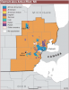
America seems to be a very ethnically divided country, so I figured it makes sense to break it up into states based on ethnic lines.
I give you the 30 states of America:

A - Northwestphalia
B - Sussex
C - West Mexico
D - Indiana
E - North Mexico
F - New Bavaria
G - Winnetou
H - West Vaterland
I - East Mexico
J - West America
K - New Indiana
L - Southwest America
M - Central Vaterland
N - Bremen
O - New Frisia
P - East America
Q - West Africa
R - New Orleans
S - South America
T - Abandoned territories
U - East Vaterland
V - East Africa
W - South Canada
X - Catholica
Y - Aleutia
Z - Deutschaleutia
1 - Fjordland
2 - Suomiland
3 - Hispania
blank - Hawaii
I give you the 30 states of America:
A - Northwestphalia
B - Sussex
C - West Mexico
D - Indiana
E - North Mexico
F - New Bavaria
G - Winnetou
H - West Vaterland
I - East Mexico
J - West America
K - New Indiana
L - Southwest America
M - Central Vaterland
N - Bremen
O - New Frisia
P - East America
Q - West Africa
R - New Orleans
S - South America
T - Abandoned territories
U - East Vaterland
V - East Africa
W - South Canada
X - Catholica
Y - Aleutia
Z - Deutschaleutia
1 - Fjordland
2 - Suomiland
3 - Hispania
blank - Hawaii
gay_Aleks
from the river to the sea, Palestine will be free!
Bow down to your German overlords, you knaves!
sophie
Break My Heart
Lurking to see the ridiculous California proposals.

onejayhawk
Afflicted with reason
Guess I should have waited before putting this in the other thread.

Whomever drew that had no clue where the Bible belts are.
J
Geography was not your best subject, was it? There are exactly three.
J
Wyoming, Kansas, Nebraska, Oklahoma, and Arkansas x 2 = 10
hangman
almost-scientist
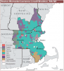
Alright, here's mine:

From west to east...
WA/OR pink: Cascadia - coffee, drizzle, grunge
WA/OR/ID red: Oregon - desert, white supremacists
CA green: Bay Area - hippies, fog, marijuana
CA sky blue: Central Valley - fruits, vegetables, wine, white supremacists, meth
CA/NV orange: Alta California - Hollywood, gambling, beaches
NV dark blue: Nevada - desert, Mormons
ID yellow: Snake River - ski resorts, potatoes
AZ purple: Arizona - desert, heat, cacti, meth
AZ/NM red: Mega Rez 1 - Navajo, Hopi, Zuni, desert, cool turquoise beads, Grand Canyon
NM/CO blue: Newer Mexico - wrong turns at Albuquerque, police violence, desert
UT/CO sky blue: ski resorts, big cities, Mormons
WY/MT orange: nothing
MT/SD green: Mega Rez 2 - Cheyenne, Crow, Lakota, wind, Mt. Rushmore
NB/KS purple: corn
ND/SD/MN pink: cold, fracking
TX orange: Texas! (smaller, but more Texas-y!)
OK blue: Oklahoma - tornadoes, Native Americans
TX white: Aggieland - insufferable A&M fans, Soviet-era architecture, general awfulness
TX sky blue: Houston - oil refineries, Cajun expats, traffic
TX green: Piney Woods - trees, lakes, mobile homes
LA red: Best Louisiana - Cajuns, Creoles, spicy food, oil, hurricanes, pretty girls
LA yellow: Evil Louisiana: evil
AK/MO white: Greater Arkansas - Ozarks, retired people, bored grandchildren
MO pink: Lesser Missouri - police violence
IA/MN/IL sky blue: Iowa - corn, random patch of liberal voters
MS/AK orange: Mississippi - African Americans, random patch of liberal voters, humidity, cities named for places in ancient Egypt (Memphis, etc.)
WI/MI white: Almost Canada - cold, Green Bay Packers, goofy militia groups
IL green: Chicago - corruption
IL/IN/OH orange: Midwest - things, stuff
KY/TN dark red: Elvisland - rivers, unintelligible accents
MS/AL/GA sky blue: Dixie - southern belles, KKK chapters, cotton, funny accents, poverty
MS/AL/FL blue: Redneck Riviera - pretty beaches, hurricanes
MI dark red: Detroit - cars, misery
PA/NY sky blue: Rust Belt - manufacturing, snow, people who call soda "pop"
WV red: Appalachia - folk music, coal, poverty, white people
GA green: Atlanta - big city, traffic, hip hop
FL/GA purple: First Coast - Gullah, swamps
FL orange: Florida - Cuban expats, Disneyland, hurricanes, oranges
NC/SC yellow: Carolina - weird-but-tasty BBQ, beaches, phallic-looking skyscrapers
VA pink: Virginia - beaches, bros, navy personnel, tobacco farms
VA/ML dark red: Capital - politicians, crime, cities with no skyline
NJ/DE blue: Atlantic Coast - Philadelphia, salt water taffy
NJ/NY red: New York City - skyscrapers, I <3 NY shirts, hip hop
MA/CT/RI purple: New England - fishing, hilarious accents, prestigious universities
VT/NH/ME green: trees, hippies, libertarians
Spoiler :
From west to east...
WA/OR pink: Cascadia - coffee, drizzle, grunge
WA/OR/ID red: Oregon - desert, white supremacists
CA green: Bay Area - hippies, fog, marijuana
CA sky blue: Central Valley - fruits, vegetables, wine, white supremacists, meth
CA/NV orange: Alta California - Hollywood, gambling, beaches
NV dark blue: Nevada - desert, Mormons
ID yellow: Snake River - ski resorts, potatoes
AZ purple: Arizona - desert, heat, cacti, meth
AZ/NM red: Mega Rez 1 - Navajo, Hopi, Zuni, desert, cool turquoise beads, Grand Canyon
NM/CO blue: Newer Mexico - wrong turns at Albuquerque, police violence, desert
UT/CO sky blue: ski resorts, big cities, Mormons
WY/MT orange: nothing
MT/SD green: Mega Rez 2 - Cheyenne, Crow, Lakota, wind, Mt. Rushmore
NB/KS purple: corn
ND/SD/MN pink: cold, fracking
TX orange: Texas! (smaller, but more Texas-y!)
OK blue: Oklahoma - tornadoes, Native Americans
TX white: Aggieland - insufferable A&M fans, Soviet-era architecture, general awfulness
TX sky blue: Houston - oil refineries, Cajun expats, traffic
TX green: Piney Woods - trees, lakes, mobile homes
LA red: Best Louisiana - Cajuns, Creoles, spicy food, oil, hurricanes, pretty girls
LA yellow: Evil Louisiana: evil
AK/MO white: Greater Arkansas - Ozarks, retired people, bored grandchildren
MO pink: Lesser Missouri - police violence
IA/MN/IL sky blue: Iowa - corn, random patch of liberal voters
MS/AK orange: Mississippi - African Americans, random patch of liberal voters, humidity, cities named for places in ancient Egypt (Memphis, etc.)
WI/MI white: Almost Canada - cold, Green Bay Packers, goofy militia groups
IL green: Chicago - corruption
IL/IN/OH orange: Midwest - things, stuff
KY/TN dark red: Elvisland - rivers, unintelligible accents
MS/AL/GA sky blue: Dixie - southern belles, KKK chapters, cotton, funny accents, poverty
MS/AL/FL blue: Redneck Riviera - pretty beaches, hurricanes
MI dark red: Detroit - cars, misery
PA/NY sky blue: Rust Belt - manufacturing, snow, people who call soda "pop"
WV red: Appalachia - folk music, coal, poverty, white people
GA green: Atlanta - big city, traffic, hip hop
FL/GA purple: First Coast - Gullah, swamps
FL orange: Florida - Cuban expats, Disneyland, hurricanes, oranges
NC/SC yellow: Carolina - weird-but-tasty BBQ, beaches, phallic-looking skyscrapers
VA pink: Virginia - beaches, bros, navy personnel, tobacco farms
VA/ML dark red: Capital - politicians, crime, cities with no skyline
NJ/DE blue: Atlantic Coast - Philadelphia, salt water taffy
NJ/NY red: New York City - skyscrapers, I <3 NY shirts, hip hop
MA/CT/RI purple: New England - fishing, hilarious accents, prestigious universities
VT/NH/ME green: trees, hippies, libertarians
Attachments

Zack
99% hot gas
^ How is that less of a mess?
hangman
almost-scientist
WyomingMissouri, Kansas, Nebraska, Oklahoma, and Arkansas x 2 = 10
FTFY.
hangman
almost-scientist
America seems to be a very ethnically divided country, so I figured it makes sense to break it up into states based on ethnic lines.
I give you the 30 states of America:
-snip-
It's actually more diverse than it looks, although I'm surprised it comes out looking similar to mine in many aspects.
^ How is that less of a mess?
Much better cultural contiguity. i.e., ethnic, political, economic, and cultural groups aren't split from each other by state lines. Some improvement with respect to geographical barriers. Also fixes the whole NYC-being-in-three-states thing.
I'm kind of iffy about the Midwest though, I'm not as familiar with the intricacies of culture there.
onejayhawk
Afflicted with reason
Wyoming, Kansas, Nebraska, Oklahoma, and Arkansas x 2 = 10
Missouri is one each. You have to give Jesusland two Senators, so the total is 9.
FTFY.
Close but no banana.
J
Evie
Pronounced like Eevee
Yeah, see the part where I said *about* 10 instead of *exactly 10*? That's precisely because I wasn't 100% certain every last seat in the region was actually red-to-deep-red. But by and large they are, so that's still a pretty big net loss in red seats 
Goodfella
Showing results for
America seems to be a very ethnically divided country, so I figured it makes sense to break it up into states based on ethnic lines.
Yeah but that map shows pluralities, not majorities. So, for example, your 'West Africa' would probably still have a hefty white majority. Its whites are just divided between German, English, Irish, 'American,' and so on. And there's little difference between German Americans, English Americans, etc and most other types of white American which really makes the divisions along these lines kind of pointless (not that dividing the country along ethnic lines would be a particularly good idea anyway, but I'm sure you know that).
Domen
Misico dux Vandalorum
warpus said:America seems to be a very ethnically divided country, so I figured it makes sense to break it up into states based on ethnic lines.
Do not forget to create autonomous Free Cities based on ethnic divisions - below a couple of suggestions:
Bostún (Boston), Nua Éire (New Ireland):

Detrotsburg (Detroit), Deutsch-Westafrika (German West Africa):

Attachments
Similar threads
- Replies
- 26
- Views
- 991
- Replies
- 73
- Views
- 3K